
Christine's Duck Creek Guidebook!
Sightseeing
Kid Favorite!!
From the Duck Creek Visitor Center, take Highway 14 east. Turn left on Mammoth Creek Road, in about 5 miles you will see a sign for Mammoth Cave, turn right and follow the signs to Mammoth Cave.
***Bring flashlights
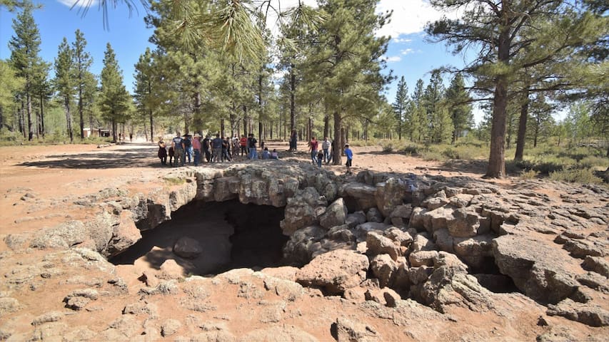
Mammoth Cave Road
Mammoth Cave RoadKid Favorite!!
From the Duck Creek Visitor Center, take Highway 14 east. Turn left on Mammoth Creek Road, in about 5 miles you will see a sign for Mammoth Cave, turn right and follow the signs to Mammoth Cave.
***Bring flashlights
Right off the SR 14 west of the village. Duck Creek pond is a picturesque spot to fish, sightsee, hike, and picnic!! It is surrounded by ponderosa pine and aspen trees and stocked with trout!!
*** Fishing Licenses are required in Utah for fishermen over 12. They can be bought at Loose Wheels and True Value in the Village!!
Duck Creek Pond
Right off the SR 14 west of the village. Duck Creek pond is a picturesque spot to fish, sightsee, hike, and picnic!! It is surrounded by ponderosa pine and aspen trees and stocked with trout!!
*** Fishing Licenses are required in Utah for fishermen over 12. They can be bought at Loose Wheels and True Value in the Village!!
What are ice caves? Glad you asked... Ice caves are caves in bedrock that host year-round ice. They differ from caves formed within ice, which are designated glacial caves. Ice caves are exceptional because they are not only scarce, but they are located far outside zones of permafrost. Duck Creek Ice Cave, formed in a sinkhole on the Markagunt Plateau, is an example of a cold trap ice cave.
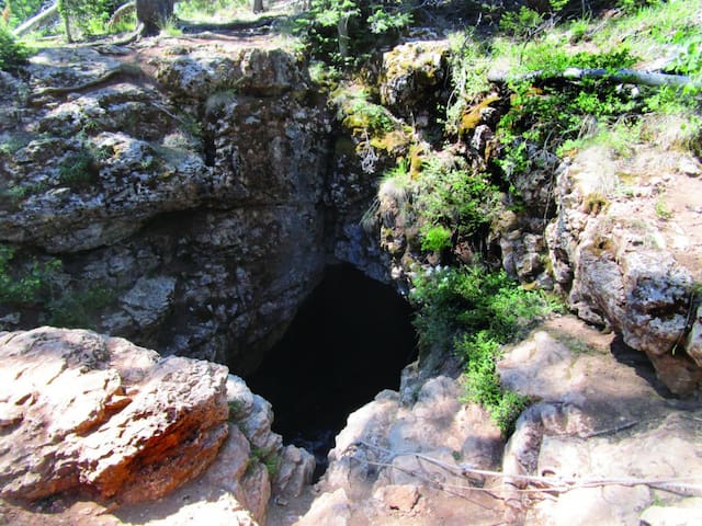
Ice Cave Peak
What are ice caves? Glad you asked... Ice caves are caves in bedrock that host year-round ice. They differ from caves formed within ice, which are designated glacial caves. Ice caves are exceptional because they are not only scarce, but they are located far outside zones of permafrost. Duck Creek Ice Cave, formed in a sinkhole on the Markagunt Plateau, is an example of a cold trap ice cave.
Take the gravel road south from Duck Creek Visitors center. At the first junction, continue towards Navajo lake. At the end of the meadow, turn left at the junction, road ends at the trailhead. The trail is 3/4 of a mile long.
Named for the water fall that flows out of the side of the cliff, this trail is a local favorite. The trail provides spectacular views of Zion National Park and beyond. The water that flows over the falls is supplied by Navajo Lake through an underground lava tube or sink hole. The water flows a couple miles underground through the tube before exiting at the Virgin River Rim.
***Cameras are a must!
41 Recomendado por los habitantes de la zona
Cascade Falls Trail
Take the gravel road south from Duck Creek Visitors center. At the first junction, continue towards Navajo lake. At the end of the meadow, turn left at the junction, road ends at the trailhead. The trail is 3/4 of a mile long.
Named for the water fall that flows out of the side of the cliff, this trail is a local favorite. The trail provides spectacular views of Zion National Park and beyond. The water that flows over the falls is supplied by Navajo Lake through an underground lava tube or sink hole. The water flows a couple miles underground through the tube before exiting at the Virgin River Rim.
***Cameras are a must!
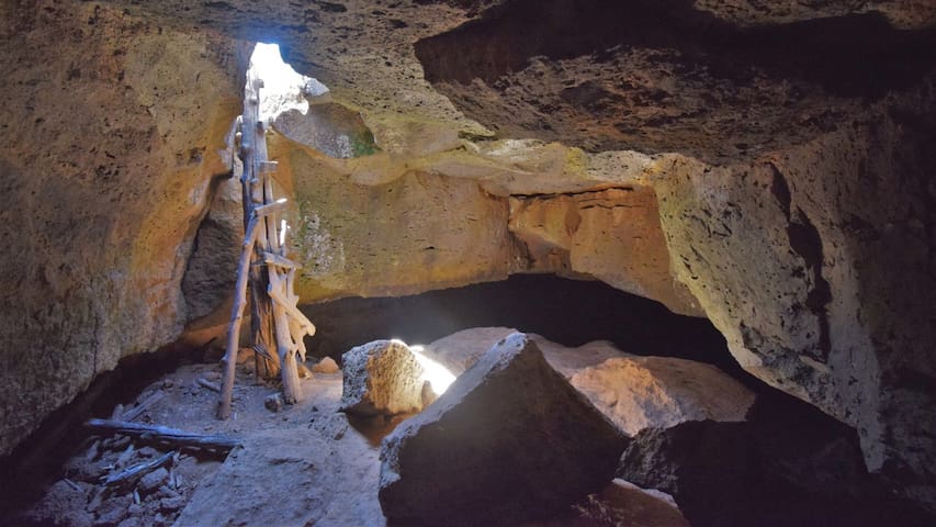
From the Duck Creek Visitor Center, head east on Highway 14 for 1.5 miles. Turn left onto Mammoth Creek Road (there is a sign). Follow for about 2.7 miles, then turn right onto a small dirt road. There is a small sign that says Bowers Flat, so keep an eye out. Follow the road for 0.6 miles until you find a small parking area. There is a sign for Bowers Cave at the trailhead. There is a short walk to the mouth of the cave.
Bower Cave is a bit smaller than Mammoth, but just as much fun. One thing our boys enjoyed was the ladder that allows entrance to the cave. There is a drop of about twelve feet to the floor of the cave, and a sturdy, but crooked ladder is the only way down. Once inside the cave, you’ll need light. This is because the entrance is very small and very little sunlight hits the cave floor. There are also several passages to explore that lead a good distance from the opening.Since Bower is more of a lava tube than a cave, it has a fairly high ceiling in most places and a nice round shape. The tube leads a short distance before turning back on itself until your back is to the entrance. From there, you can follow the tunnel for several hundred feet.The floor of the cave is rough and uneven, so keep the light focused down as you spelunk along. Further on the cave is very wet, so don’t wear shoes that you want to keep nice. There were many puddles and gummy mud is unavoidable if you wish to continue to the end of the cave. It was beautifully cool inside the cave, though. Bower Cave is home to seven different species of bats, so it is closed to protect them during the winter months from October to April.
***Bring flashlights. This cave has some dark sections.
6 Recomendado por los habitantes de la zona
Bowers Caves
From the Duck Creek Visitor Center, head east on Highway 14 for 1.5 miles. Turn left onto Mammoth Creek Road (there is a sign). Follow for about 2.7 miles, then turn right onto a small dirt road. There is a small sign that says Bowers Flat, so keep an eye out. Follow the road for 0.6 miles until you find a small parking area. There is a sign for Bowers Cave at the trailhead. There is a short walk to the mouth of the cave.
Bower Cave is a bit smaller than Mammoth, but just as much fun. One thing our boys enjoyed was the ladder that allows entrance to the cave. There is a drop of about twelve feet to the floor of the cave, and a sturdy, but crooked ladder is the only way down. Once inside the cave, you’ll need light. This is because the entrance is very small and very little sunlight hits the cave floor. There are also several passages to explore that lead a good distance from the opening.Since Bower is more of a lava tube than a cave, it has a fairly high ceiling in most places and a nice round shape. The tube leads a short distance before turning back on itself until your back is to the entrance. From there, you can follow the tunnel for several hundred feet.The floor of the cave is rough and uneven, so keep the light focused down as you spelunk along. Further on the cave is very wet, so don’t wear shoes that you want to keep nice. There were many puddles and gummy mud is unavoidable if you wish to continue to the end of the cave. It was beautifully cool inside the cave, though. Bower Cave is home to seven different species of bats, so it is closed to protect them during the winter months from October to April.
***Bring flashlights. This cave has some dark sections.
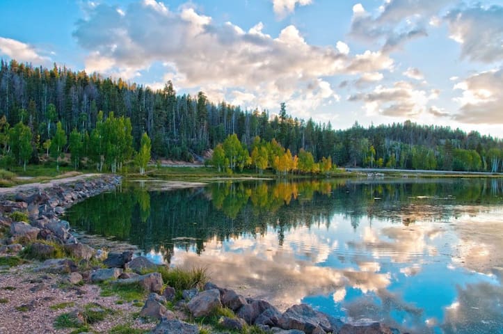
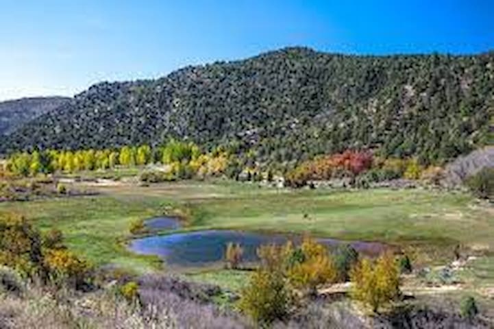
From the Duck Creek Visitors center, take Highway 14 west, turn south at the Navajo Lake junction. The Lake is about 4 miles.
Call it Navajo Lake . . . or call it "Blue Mirror of Heaven" as the Indians did. At Navajo Lake you'll find... Sky Blue Waters, Fresh Air, Delightfully Cool Nights, and scenic grandeur that will give new meaning to the joy of living! Know for some of the best trout fishing in the southwestern region, we have a network of lakes and streams that are within minutes of Duck Creek Village and are stocked throughout the spring and summer seasons. Navajo Lake provides visitors with boating, swimming, canoeing, trail biking, and fishing. The lake boasts rainbow and brook trout.
64 Recomendado por los habitantes de la zona
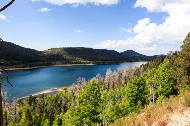
Navajo Lake
From the Duck Creek Visitors center, take Highway 14 west, turn south at the Navajo Lake junction. The Lake is about 4 miles.
Call it Navajo Lake . . . or call it "Blue Mirror of Heaven" as the Indians did. At Navajo Lake you'll find... Sky Blue Waters, Fresh Air, Delightfully Cool Nights, and scenic grandeur that will give new meaning to the joy of living! Know for some of the best trout fishing in the southwestern region, we have a network of lakes and streams that are within minutes of Duck Creek Village and are stocked throughout the spring and summer seasons. Navajo Lake provides visitors with boating, swimming, canoeing, trail biking, and fishing. The lake boasts rainbow and brook trout.
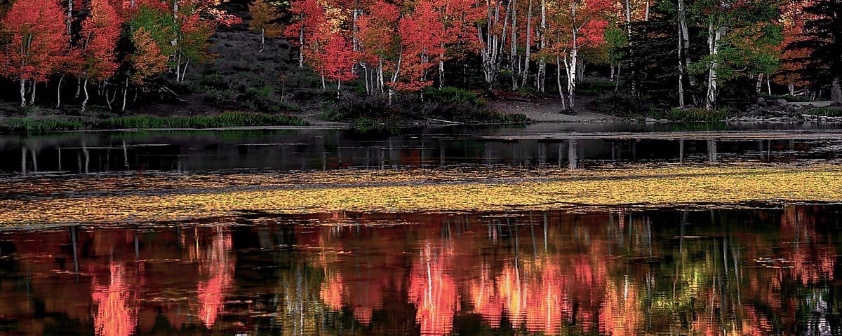
From the Duck Creek Visitors Center, take SR 14 east. Just before the village, turn north at the sign for Aspen Mirror Lake. This road ends at the trailhead, the trail is about 200 yards to the pond.
Navajo lake is surrounded by Aspen trees, making this a spectacular destination in the fall. Cameras are a must! Though the lake is not very large it is stocked with rainbow trout providing some fishing opportunities. Cool water reflects the big blue Utah sky, offering a picturesque place to hike, relax, meditate, SUP, kayak, or fish. Rainbow trout fill the lake. You might also spot wildlife like ducks, large birds of prey (hawks, eagles, and falcons), deer, and antelope.
Aspen Mirror Lake is one of the top recreational locations in Duck Creek Village.
39 Recomendado por los habitantes de la zona
Aspen-Mirror Lake
From the Duck Creek Visitors Center, take SR 14 east. Just before the village, turn north at the sign for Aspen Mirror Lake. This road ends at the trailhead, the trail is about 200 yards to the pond.
Navajo lake is surrounded by Aspen trees, making this a spectacular destination in the fall. Cameras are a must! Though the lake is not very large it is stocked with rainbow trout providing some fishing opportunities. Cool water reflects the big blue Utah sky, offering a picturesque place to hike, relax, meditate, SUP, kayak, or fish. Rainbow trout fill the lake. You might also spot wildlife like ducks, large birds of prey (hawks, eagles, and falcons), deer, and antelope.
Aspen Mirror Lake is one of the top recreational locations in Duck Creek Village.
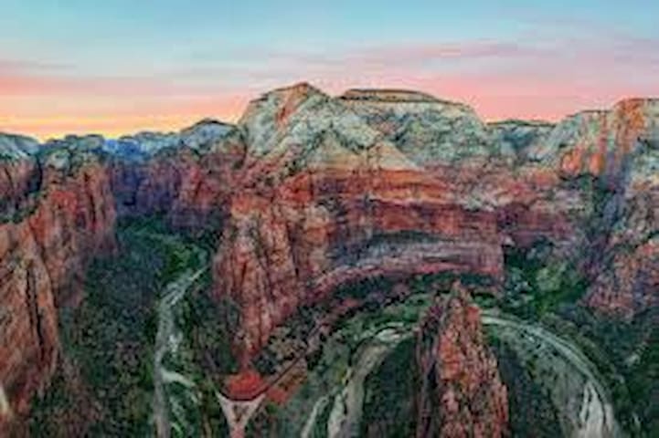
Zion National Park is like the set of a movie that’s so grand you might think its fake. Follow the paths where native people and pioneers walked. Gaze up at massive sandstone cliffs of cream, pink, and red that soar into a brilliant blue sky. Experience wilderness in a narrow slot canyon. Zion’s unique array of plants and animals will enchant you as you absorb the rich history of the past and enjoy the excitement of present day adventures. he highlight of Zion National Park is an expansive canyon. Averaging 2,000 feet deep, Zion Canyon offers hiking opportunities along its floor in the 20 to 30 foot wide area known as The Narrows and the challenging area known as The Subway. Swimming is also permitted in this area of the Virgin River. The hiking in Zion National Park is world famous for its views of sweeping vistas, clear pools, natural arches, and narrow canyons. Trails range from half-mile paved hikes to multi-day backpacking routes, so hikers of all abilities will have days worth of hiking to explore. The majority of the popular trails like Angels Landing and Emerald Pools are in Zion Canyon, but there are many other fantastic (and less-traveled) trails in the Kolob and East Zion regions of the park. Plus, the region surrounding the park is home to a sprawling desert reserve and coveted multi-use trails that shouldn’t go unseen.
***Youth programs are designed specifically for families and children. Junior Ranger Activity Booklets are available at the Zion Canyon Visitor Center and Human History Museum.
86 Recomendado por los habitantes de la zona
Parque Nacional Zion
95 Zion Park BlvdZion National Park is like the set of a movie that’s so grand you might think its fake. Follow the paths where native people and pioneers walked. Gaze up at massive sandstone cliffs of cream, pink, and red that soar into a brilliant blue sky. Experience wilderness in a narrow slot canyon. Zion’s unique array of plants and animals will enchant you as you absorb the rich history of the past and enjoy the excitement of present day adventures. he highlight of Zion National Park is an expansive canyon. Averaging 2,000 feet deep, Zion Canyon offers hiking opportunities along its floor in the 20 to 30 foot wide area known as The Narrows and the challenging area known as The Subway. Swimming is also permitted in this area of the Virgin River. The hiking in Zion National Park is world famous for its views of sweeping vistas, clear pools, natural arches, and narrow canyons. Trails range from half-mile paved hikes to multi-day backpacking routes, so hikers of all abilities will have days worth of hiking to explore. The majority of the popular trails like Angels Landing and Emerald Pools are in Zion Canyon, but there are many other fantastic (and less-traveled) trails in the Kolob and East Zion regions of the park. Plus, the region surrounding the park is home to a sprawling desert reserve and coveted multi-use trails that shouldn’t go unseen.
***Youth programs are designed specifically for families and children. Junior Ranger Activity Booklets are available at the Zion Canyon Visitor Center and Human History Museum.
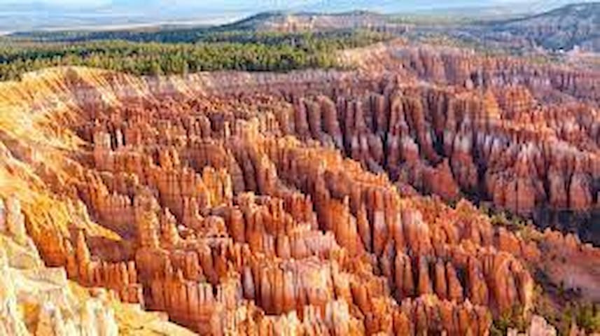
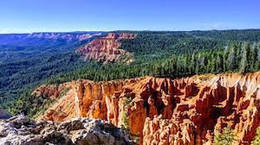
Bryce Canyon National Park is the land of the “hoodoos”, or pillars of rock, that have both inspired and reverenced people for hundreds of years. Red Rocks, Pink Cliffs, and Endless Vistas
Hoodoos (irregular columns of rock) exist on every continent, but here is the largest concentration found anywhere on Earth. Situated along a high plateau at the top of the Grand Staircase, the park's high elevations include numerous life communities, fantastic dark skies, and geological wonders that defy description. Bryce Canyon National Park overlooks astonishing rock formations and is awe-inspiring.
***Bryce Canyon has a ranger program. Ranger programs are always free, though some (such as winter snowshoe hikes and full moon hikes) require advance sign-up or are subject to a lottery.
45 Recomendado por los habitantes de la zona
Bryce Canyon City
Bryce Canyon National Park is the land of the “hoodoos”, or pillars of rock, that have both inspired and reverenced people for hundreds of years. Red Rocks, Pink Cliffs, and Endless Vistas
Hoodoos (irregular columns of rock) exist on every continent, but here is the largest concentration found anywhere on Earth. Situated along a high plateau at the top of the Grand Staircase, the park's high elevations include numerous life communities, fantastic dark skies, and geological wonders that defy description. Bryce Canyon National Park overlooks astonishing rock formations and is awe-inspiring.
***Bryce Canyon has a ranger program. Ranger programs are always free, though some (such as winter snowshoe hikes and full moon hikes) require advance sign-up or are subject to a lottery.
Coral Pink Sand Dunes State Park, lying west of Kanab, is a natural wonder of red sand dunes pressed against the edge of the Moquith Mountains. Venture onto a shifting sea of red sand. Changed by winds, these mountains and hills of sand can move as much as 50 feet per year. With areas for off-highway vehicle enthusiasts and those with non-motorized pursuits, the dunes offer adventures for all. Westerly winds carry tiny grains of sand, composed of eroded Navajo sandstone, and shapes them into high rippled dunes. The 3,730-acre state park is the only dune field on the Colorado Plateau. You can study the unique plants and animals living there including the rare Coral Pink beetle, or drive off-highway vehicles (OHVs) on over 2,000 sandy acres. Four-wheel riders like the South Boundary Trail and Sand Highway for family off-road fun.
6 Recomendado por los habitantes de la zona
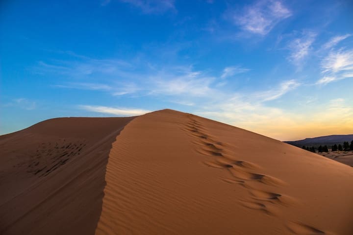
Coral Pink Sand Dunes Road
Coral Pink Sand Dunes RoadCoral Pink Sand Dunes State Park, lying west of Kanab, is a natural wonder of red sand dunes pressed against the edge of the Moquith Mountains. Venture onto a shifting sea of red sand. Changed by winds, these mountains and hills of sand can move as much as 50 feet per year. With areas for off-highway vehicle enthusiasts and those with non-motorized pursuits, the dunes offer adventures for all. Westerly winds carry tiny grains of sand, composed of eroded Navajo sandstone, and shapes them into high rippled dunes. The 3,730-acre state park is the only dune field on the Colorado Plateau. You can study the unique plants and animals living there including the rare Coral Pink beetle, or drive off-highway vehicles (OHVs) on over 2,000 sandy acres. Four-wheel riders like the South Boundary Trail and Sand Highway for family off-road fun.
Strawberry Point is a place locally renowned for its panoramic views down into Zion National Park and surrounding areas from on top of the Virgin River rim. Awesome view of lots of untouched wilderness and only a short hike from the road. There is a rocky area you can walk out on out over the edge to get an even better look at the valley. Reminds me of a smaller version of Bryce Canyon
18 Recomendado por los habitantes de la zona
Strawberry Point
Strawberry Point is a place locally renowned for its panoramic views down into Zion National Park and surrounding areas from on top of the Virgin River rim. Awesome view of lots of untouched wilderness and only a short hike from the road. There is a rocky area you can walk out on out over the edge to get an even better look at the valley. Reminds me of a smaller version of Bryce Canyon
City/town information
What is Brian Head Utah known for?
Brian Head offers The Greatest Snow on Earth, with annual snowfall of over 360 inches, and Utah's highest base elevation. Covering over 650 acres, the Brian Head Resort has two connected mountains, Giant Steps and Navajo, offering 71 runs and 8 chair lifts. The ski resort has two central base lodges; the Navajo Lodge Learning Center and the recently remodeled Giant Steps Lodge. The ski resort amenities across the two lodges include ski and snowboard rentals and repair, a retail shop with ski and snowboard gear and souvenirs, and a ski and snowboard school.
Winter Activities:
Snowboarding
Skiing
Tubing
Ice Skating
Snowmobiling
Cross Country Skiing
Snowshoeing
Spa & Massage at Noorish Spa
Summer Activities:
Mountain Biking
Scenic Lift Ride
Cliff Hanger Climbing Wall
Avalanche Tubing
Ridge Runner Zip Line
Crooked Arrow Archery
Hiking: Family Adventure Trail
Peak Shot Bungee Trampoline
Disc Golf
Fishing at Bristlecone Pond
Motorsports
Kayaking at Bristlecone Pond
Paddle boarding at Bristlecone Pond
Swimming at Bristlecone Pond
Hiking at Cedar Breaks National Monument and Town Trails
Biking on the Town Trails
ATVing in Dry Lakes and Town Trails
Barbeque or Picnic at Bristlecone Park & Pond
Spa & Massage at Noorish Spa (at Best Western Premier)
Archery at Brian Head Resort
Star Gazing at Cedar Breaks National Monument
Bird Watching in Dixie National Forest
***For the kids!!! Become a Junior Ranger at Cedar Breaks National Monument :Pick up a Junior Ranger workbook at the Visitor Center. Complete the activities & return it to Cedar Breaks Visitor Center. Get your badge!
139 Recomendado por los habitantes de la zona
Brian Head
What is Brian Head Utah known for?
Brian Head offers The Greatest Snow on Earth, with annual snowfall of over 360 inches, and Utah's highest base elevation. Covering over 650 acres, the Brian Head Resort has two connected mountains, Giant Steps and Navajo, offering 71 runs and 8 chair lifts. The ski resort has two central base lodges; the Navajo Lodge Learning Center and the recently remodeled Giant Steps Lodge. The ski resort amenities across the two lodges include ski and snowboard rentals and repair, a retail shop with ski and snowboard gear and souvenirs, and a ski and snowboard school.
Winter Activities:
Snowboarding
Skiing
Tubing
Ice Skating
Snowmobiling
Cross Country Skiing
Snowshoeing
Spa & Massage at Noorish Spa
Summer Activities:
Mountain Biking
Scenic Lift Ride
Cliff Hanger Climbing Wall
Avalanche Tubing
Ridge Runner Zip Line
Crooked Arrow Archery
Hiking: Family Adventure Trail
Peak Shot Bungee Trampoline
Disc Golf
Fishing at Bristlecone Pond
Motorsports
Kayaking at Bristlecone Pond
Paddle boarding at Bristlecone Pond
Swimming at Bristlecone Pond
Hiking at Cedar Breaks National Monument and Town Trails
Biking on the Town Trails
ATVing in Dry Lakes and Town Trails
Barbeque or Picnic at Bristlecone Park & Pond
Spa & Massage at Noorish Spa (at Best Western Premier)
Archery at Brian Head Resort
Star Gazing at Cedar Breaks National Monument
Bird Watching in Dixie National Forest
***For the kids!!! Become a Junior Ranger at Cedar Breaks National Monument :Pick up a Junior Ranger workbook at the Visitor Center. Complete the activities & return it to Cedar Breaks Visitor Center. Get your badge!
This is a cool place to see petroglyphs up close. It is located about 22 miles outside of Cedar City, Utah. The petroglyphs are right along the side of the road, no hiking necessary. It is truly mystifying that these ancient writings are see here for us to see. Amazing!
The Parowan Gap is one of my favorite places to go to capture the feeling of stepping back in time. There is a quiet there that only adds to the experience of seeing the incredible petroglyphs. The site is well-maintained and easily accessible for both young children and their grandparents.
The petroglyphs are fenced but easily viewed and photographed without any special equipment. Be sure to walk the path through the gap as there are petroglyphs throughout the area. A quick 30 minute visit will give you the flavor of the area, but I find that I spend about 90 minutes when I visit. Arriving at sunrise or sunset it particularly amazing, but Parowan Gap is wonderful any time of day.
***Just as you drive thru Parowan Gap you will pass a pull out for a location that has easily accessible dinosaur tracks!!!
8 Recomendado por los habitantes de la zona
Parowan
This is a cool place to see petroglyphs up close. It is located about 22 miles outside of Cedar City, Utah. The petroglyphs are right along the side of the road, no hiking necessary. It is truly mystifying that these ancient writings are see here for us to see. Amazing!
The Parowan Gap is one of my favorite places to go to capture the feeling of stepping back in time. There is a quiet there that only adds to the experience of seeing the incredible petroglyphs. The site is well-maintained and easily accessible for both young children and their grandparents.
The petroglyphs are fenced but easily viewed and photographed without any special equipment. Be sure to walk the path through the gap as there are petroglyphs throughout the area. A quick 30 minute visit will give you the flavor of the area, but I find that I spend about 90 minutes when I visit. Arriving at sunrise or sunset it particularly amazing, but Parowan Gap is wonderful any time of day.
***Just as you drive thru Parowan Gap you will pass a pull out for a location that has easily accessible dinosaur tracks!!!
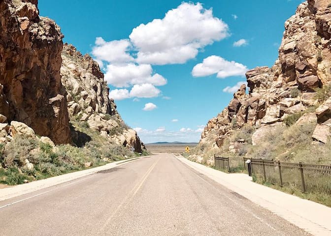
Raw nature surrounds Kanab, a Wild West town in the red heart of southwest Utah's rugged canyon country. Filled with friendly locals, classy dining, lodging and campgrounds, and interesting historical sites, the compact town, lying near the Arizona border, is the gateway to three iconic national parks, five national monuments, a national recreation area, and a couple state parks. These spectacular parklands, all a day trip from Kanab, are realms of solitude, freedom, rock, and sky. The Kanab area also offers a wealth of outdoor adventures, including hiking, photography, off-roading, canyoneering, rock climbing, mountain and road biking, sightseeing, and some of Utah's best scenic drives.
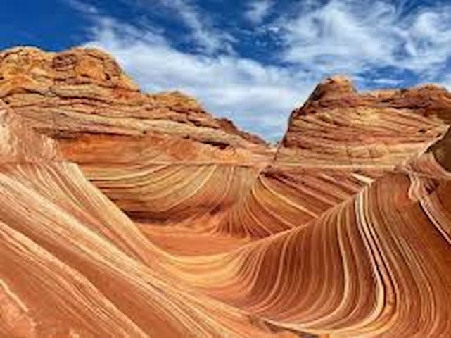
The Kanab area is a national scenic treasure with some of the planet's most spectacular vistas and rock formations. Buckskin Gulch, The Wave, and White Pocket, all east of Kanab, are three special areas that are simply out of this world.
Buckskin Gulch, one of the longest and deepest slot canyons in the United States, runs more than 13 miles to Paria Canyon. Hiking Buckskin is an extreme adventure, with wading, scrambling, and swimming through its dark passage. The best hike starts at Wire Pass Trailhead and heads down the canyon to the Paria River, then back to White House Trailhead for a 21-mile loop.
White Pocket is an impressive and remote area of swirling sandstones reached by a long 4x4 road in northern Arizona's Vermilion Cliffs National Monument. Photographers and hikers love exploring its slickrock sculptures reflected in pools of water.
The Wave in the Coyote Buttes area by the Arizona border is beautiful with its curved strata breaking like a sandstone wave. Visitation at the fragile area is limited to 20 people a day. Permits can be reserved ahead through an online lottery or by showing up at the Grand Staircase-Escalante National Monument Visitor Center in Kanab for next-day hikes. Nearby are more wonders like Melody Arch, Top Rock, Sand Cove, and the Second Wave.
31 Recomendado por los habitantes de la zona
Kanab
Raw nature surrounds Kanab, a Wild West town in the red heart of southwest Utah's rugged canyon country. Filled with friendly locals, classy dining, lodging and campgrounds, and interesting historical sites, the compact town, lying near the Arizona border, is the gateway to three iconic national parks, five national monuments, a national recreation area, and a couple state parks. These spectacular parklands, all a day trip from Kanab, are realms of solitude, freedom, rock, and sky. The Kanab area also offers a wealth of outdoor adventures, including hiking, photography, off-roading, canyoneering, rock climbing, mountain and road biking, sightseeing, and some of Utah's best scenic drives.
The Kanab area is a national scenic treasure with some of the planet's most spectacular vistas and rock formations. Buckskin Gulch, The Wave, and White Pocket, all east of Kanab, are three special areas that are simply out of this world.
Buckskin Gulch, one of the longest and deepest slot canyons in the United States, runs more than 13 miles to Paria Canyon. Hiking Buckskin is an extreme adventure, with wading, scrambling, and swimming through its dark passage. The best hike starts at Wire Pass Trailhead and heads down the canyon to the Paria River, then back to White House Trailhead for a 21-mile loop.
White Pocket is an impressive and remote area of swirling sandstones reached by a long 4x4 road in northern Arizona's Vermilion Cliffs National Monument. Photographers and hikers love exploring its slickrock sculptures reflected in pools of water.
The Wave in the Coyote Buttes area by the Arizona border is beautiful with its curved strata breaking like a sandstone wave. Visitation at the fragile area is limited to 20 people a day. Permits can be reserved ahead through an online lottery or by showing up at the Grand Staircase-Escalante National Monument Visitor Center in Kanab for next-day hikes. Nearby are more wonders like Melody Arch, Top Rock, Sand Cove, and the Second Wave.
Food scene
Martin's Corner - THE DELI
815 Movie Ranch Rd, Duck Creek Village, UT
Go get something yummy on the patio at The Deli… it’s gonna be a beautiful day on the mountain! You will enjoy over two dozen HOMEMADE menu items! Craft beer, handcrafted Sangrias and Mimosas available. #1 on TripAdvisor, come see why!
****I LOVE the Watermelon Salad and the Fire Roasted Turkey Sandwich!!! My mouth is watering just thinking about it!!!
28 Recomendado por los habitantes de la zona

Martin's Corner Deli
815 Movie Ranch RoadMartin's Corner - THE DELI
815 Movie Ranch Rd, Duck Creek Village, UT
Go get something yummy on the patio at The Deli… it’s gonna be a beautiful day on the mountain! You will enjoy over two dozen HOMEMADE menu items! Craft beer, handcrafted Sangrias and Mimosas available. #1 on TripAdvisor, come see why!
****I LOVE the Watermelon Salad and the Fire Roasted Turkey Sandwich!!! My mouth is watering just thinking about it!!!
Hot Mama's Pizza and Brew
745 Movie Ranch Rd, Duck Creek Village UT
No surprise, this is my boys favorite!! Excellent food, excellent service. The thin crust pizza is so crispy and delicate, but packed full with flavor and hot, salty, melt goodness that just makes you swoon.
PRO TIP : You can call in a carry-out order a few hours early & they let you schedule a pickup. They even call you when it was ready! AMAZING!
45 Recomendado por los habitantes de la zona
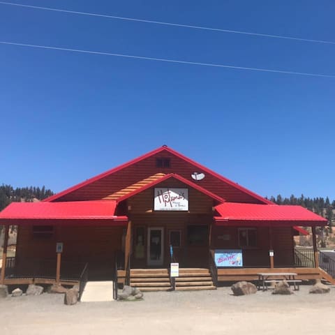
Hot Mama's Pizza & Brew
745 Movie Ranch RdHot Mama's Pizza and Brew
745 Movie Ranch Rd, Duck Creek Village UT
No surprise, this is my boys favorite!! Excellent food, excellent service. The thin crust pizza is so crispy and delicate, but packed full with flavor and hot, salty, melt goodness that just makes you swoon.
PRO TIP : You can call in a carry-out order a few hours early & they let you schedule a pickup. They even call you when it was ready! AMAZING!
Aunt Sue's Chalet
725 Movie Ranch Rd, Duck Creek Village, UT
HOME-STYLE MEALS & HOME-STYLE FEELING
Aunt Sues Chalet, is the only Duck Creek restaurant open 364 days a year. You will always find that their meals have a home-cooked feeling at reasonable prices. The salad bar is open on weekends during the winter months and every day during the summer months.
35 Recomendado por los habitantes de la zona
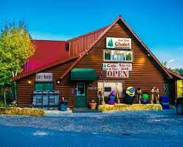
Aunt Sue's Chalet
725 Movie Ranch RdAunt Sue's Chalet
725 Movie Ranch Rd, Duck Creek Village, UT
HOME-STYLE MEALS & HOME-STYLE FEELING
Aunt Sues Chalet, is the only Duck Creek restaurant open 364 days a year. You will always find that their meals have a home-cooked feeling at reasonable prices. The salad bar is open on weekends during the winter months and every day during the summer months.
Local Information
Duck Creek Village is the gateway to several National Parks and nearby summer hiking, fishing, camping, biking and a variety of winter activities. Duck Creek is surrounded by beautiful mountain scenery and offers a myriad of recreation activities for all seasons. The village includes shops and restaurants, lodges, inns, cabin rentals and a campground for the more adventurous overnight guest. Many visitors enjoy this resort so much that they choose to make Duck Creek their permanent home, and there are several subdivisions and large variety of year-round homes from which to choose.
Fun Facts about Duck Creek Village
The truly spectacular scenery of this area makes it a popular location for movie and television filming. In the 1940’s, Elizabeth Taylor called the village home on several occasions while filming Drums Along the Mohawk and National Velvet in the area. Later, Duck Creek Village was featured on the television shows How the West Was Won and Daniel Boone.
Attractions
Key Attractions & Distances
Aspen Mirror Lake Local
Navajo Lake 7 miles
Coral Pink Sand Dunes State Park 7 miles
Cascade Falls 9 miles
Cedar Breaks National Monument 20 miles
Panguitch Lake 21 miles
Brian Head Ski Resort 25 miles
Zion National Park 26 miles
Grand Staircase Escalante Monument 32 miles
Bryce Canyon National Park 52 miles
Capitol Reef National Park 164 miles
57 Recomendado por los habitantes de la zona
Duck Creek Village
Duck Creek Village is the gateway to several National Parks and nearby summer hiking, fishing, camping, biking and a variety of winter activities. Duck Creek is surrounded by beautiful mountain scenery and offers a myriad of recreation activities for all seasons. The village includes shops and restaurants, lodges, inns, cabin rentals and a campground for the more adventurous overnight guest. Many visitors enjoy this resort so much that they choose to make Duck Creek their permanent home, and there are several subdivisions and large variety of year-round homes from which to choose.
Fun Facts about Duck Creek Village
The truly spectacular scenery of this area makes it a popular location for movie and television filming. In the 1940’s, Elizabeth Taylor called the village home on several occasions while filming Drums Along the Mohawk and National Velvet in the area. Later, Duck Creek Village was featured on the television shows How the West Was Won and Daniel Boone.
Attractions
Key Attractions & Distances
Aspen Mirror Lake Local
Navajo Lake 7 miles
Coral Pink Sand Dunes State Park 7 miles
Cascade Falls 9 miles
Cedar Breaks National Monument 20 miles
Panguitch Lake 21 miles
Brian Head Ski Resort 25 miles
Zion National Park 26 miles
Grand Staircase Escalante Monument 32 miles
Bryce Canyon National Park 52 miles
Capitol Reef National Park 164 miles
Consejos para la ciudad
Viajar con niños
Horseback Riding service in Duck Creek Village, Utah
Forest Hwy 050, Duck Creek Village, UT
*Reservations Recommended
Hours:
Friday 10AM–5PM
Saturday 10AM–5PM
Sunday 10AM–5PM
Monday 10AM–5PM
Tuesday 10AM–5PM
Wednesday10AM–5PM
Thursday 10AM–5PM
They provide safe and enjoyable guided horse trail rides in spectacular dixie forest.
Facilidad para moverse por la casa
Key Attractions & Distances
Attractions
Aspen Mirror Lake Local
Navajo Lake 7 miles
Coral Pink Sand Dunes State Park 7 miles
Cascade Falls 9 miles
Cedar Breaks National Monument 20 miles
Panguitch Lake 21 miles
Brian Head Ski Resort 25 miles
Zion National Park 26 miles
Grand Staircase Escalante Monument 32 miles
Bryce Canyon National Park 52 miles
Capitol Reef National Park 164 miles
Facilidad para moverse por la casa
OHV Rentals
Duck Creek Adventure
Falcon’s Nest
Looking to hit the trails? Duck Creek Adventures and Falcons Nest offers ATV, RZR, and Snowmobile rentals. They are both located right on Movie Ranch Road!!
Costumbres y cultura
Cedar Mountain Tru Value Country Store
More than just a hardware store, they sell groceries and so much more! If you have any questions or need advice they have all the answers!! This is the small town store and they are experts about the area and are the kindest folks you'll ever meet!!!